...hunker down and watch movies! We are currently watching our second movie of the day, because outside it is cold and VERY windy. There's another Nor'Easter coming, expected to be similar to the one during this same timeframe two years ago (the one I wrote about a couple of blogs ago, which wrecked the OISFT that year).
A couple of days ago, a neighbor and I had a conversation about the fact that "we need some rain", because it has been dry here for several weeks. After we talked, I remembered that the last time I had a chat with someone about the need for rain, we had a minor Nor'easter with PLENTY of rain (i.e. flooding - remember the picture of the ducks in the street?) Now that there's another one coming, I think maybe I should stop having conversations about needing rain!
Here's the current status: both the mainland and Hatteras ferries are shut down until further notice, gusts up to 70 mph have been clocked at the Hatteras Lighthouse, and more wind and rain are expected. I've pasted the text of the latest email from the Emergency Management group below.
Here's the good news: the old timers say that, in years when the spring brings several Nor'Easters, the hurricane season is uneventful. Two years ago, that proved to be true. We had two pretty annoying Nor'Easters, with the related soundside flooding, etc. followed by a calm hurricane season. So hopefully that will hold true again this year!
From Tony Spencer, Hyde County Emergency Management:
I got the statement below earlier from Sandy in Dare County . When I had sent out the first message this afternoon, I had only what was in my head, received verbally from the Newport Weather Office. The info below emphasizes and puts much of it in writing. This storm has the potential to affect our weather for the next few days, settling back South and actually switching over to a warm core, taking on tropical characteristics and becoming a hybrid. With the significant winds expected, with models including even higher scenarios, visitors and residents should collect loose items. Significant beach erosion and ocean overwash may make Hwy 12 impassable in many spots, particular up on Hatteras Island . All of this seems very similar to the major Nor’Easter we had this same weekend two years ago.
From Sandy :
This system continues indicate a fairly intense storm off the Hatteras coast starting Sunday night through Wednesday. High winds and seas will be our problem and because of the duration of the event we can expect some minor/moderate ocean overwash and beach erosion. Very similar to what the Thanksgiving storm brought. Fire services should prepare for ocean front cottage/homes to become isolated during high tides. Power outages certainly possible as winds could exceed 50mph at times. Monitor NOAA weather radio and local news for weather updates.
From: F. Rosenstein at NOAA
Situation remains fairly similar but with increasing confidence of the evolution and track of this system. An unusual setup. Strong high pressure drops southeastward today and tomorrow with surface wave development along the leading edge front. The low will move well southeastward offshore and become a cutoff low vertically stacked with the mid level air flow. This will be down near31N 73W by Monday evening. This low will then slowly move westward with its center near 31N 76w Tuesday evening with a continued NW drift to off the GA/SC coast Thursday and will remain nearly stationary into next Saturday . There is a distinct possibility as seen by some objective parameters that this system could change from cold core asymmetric to shallow warm core symmetric as it move westward. What this means is that it could begin to take on tropical characteristics in which it could evolve into a hybrid
tropical low. Early in the season for this but with models showing this potential and a trend to move back towards warmer waters of the Gulf Stream, it could transition to that. Has happened before. Last time was early May 2001 with one farther eastward off Bermuda .
My preference this morning was a track and set up more along the Canadian model line thru day 5 Thursday and remaining nearly stationary into Saturday.
Weather...
Sunday NE winds increasing to 40 kts continuing Sunday night into Monday.
Tuesday NE 30 Kts, higher offshore. Rain coming onshore
Wednesday NE becoming more E 25-30 Good chance rain
Thursday SE 20-25 Good chance rain
Friday S 20 higher offshore Good chance rain
Saturday S 20 Again coastal rain chances
Strong NE-N winds will force waters south with tidal flooding lower Pamlico Sound . Winds become more easterly and then SE later in the week will keep up above normal tides. Greater tidal flooding west side of the Sound. The usual rough surf. Continued high winds against the Gulfstream flow for days will develop fully arisen seas and will translate very heavy swells to the beachs.
skip to main |
skip to sidebar
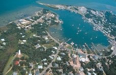
Musings, stories and photographs about my life on a small island off the coast of North Carolina.
About Me
- Ocrakate
- Ocracoke Island, NC, United States
- I am blessed and lucky to call Ocracoke Island, NC home. Ocracoke is beloved of residents and visitors, and I hope this blog will be a way for folks to keep in touch with what's going on here, both in general and in my life specifically. It's a fix for your Ocracoke jonesing!
Other blogs about Ocracoke
Links to some of my favorite Ocracoke things
Other Links
Blog Archive
-
▼
2007
(188)
-
▼
May
(30)
- Lions and tigers, definitely not. But bears, appa...
- Fish House Update
- Bloody pirates!
- Working holiday weekend
- For a good cause
- Good news?
- Sailing and snacking
- Flotsam and jetsam
- New music
- Flickering lights
- Triple digits! and why I love wind
- Roomful of wisdom
- Cold
- Sudden showers
- Learning from "Eena"
- Risque business?
- Storm debris
- Movie stars
- Learning to breathe
- A special cemetery
- Turtles and spiders and frogs, oh my!
- Froggy
- I must be immortal
- Keeping my streak intact
- A good day to...
- I can pick 'em
- Bonner Bridge replacement - you can help
- Rollercoaster spring
- Full moon
- Berkley Manor update
-
▼
May
(30)
No comments:
Post a Comment