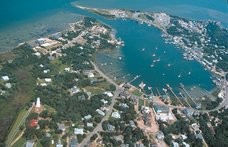
It has been very windy here all day. The wind is whistling around the corners of my house, and the awning over my living room windows has been flapping wildly. The Outer Banks area is caught between an area of very low pressure, and one of very high pressure, which is causing the wind. I heard at the Post Office tonight that some mainland ferry runs were cancelled today, but that the Hatteras ferry is (for the moment) still running. The worst of the weather is expected tomorrow.
I just received the following storm advisory in email, whic provides a little more detail for those of you who are curious.
_________________________________________________
Non-tropical coastal storm developing off the NC coast with gradually deteriorating weather conditions tonight through Wednesday night. Main impacts expected Wednesday and Wednesday night.
High wind warnings are now in effect for Carteret and outer Banks of Dare and Hyde counties from Tuesday night through Wednesday night. Winds will increase to 30 to 40 mph with higher gusts likely.
High surf will be a problem with a prolonged northeast fetch and waves in the offshore marine area building to 15 to 20 feet on Wednesday. A Gale Warning is in effect for all of the coastal waters including the sounds through Wednesday night.
Water level rises of 3 to 5 feet will be possible with long duration northeast winds across Pamlico County adjacent to Pamlico Sound, and the lower reaches of the Neuse River including southern Craven and down east Carteret counties. A coastal Flood Warning is now in effect for these areas from tonight through Wednesday night.
Ocean over wash expected from Cape Hatteras north mainly on Wednesday during the mid afternoon high tide with water levels of up to 5 to 6 feet above normal likely. A Coastal Flood Warning is in effect for the Outer Banks Dare County from late Tuesday night through Wednesday night. This will result in ocean over wash across portions of Outer Banks Dare County, especially Highway 12.
Localized flooding will be possible mainly across coastal flood prone and low lying areas. At this time significant widespread flooding is not anticipated to be a threat. One to three inches of storm total rainfall is possible through Thursday Morning.
Residents and Visitors of Ocracoke Island should pay close attention to weather updates during the next couple of days. This weather system could lead to Ferry Service interruptions and Highway 12 in Dare County being closed during Wednesday into Thursday evening.
___________________________________________
So if you're not here, it's probably a good idea not to try to come right now. And if you are here, you may be staying put for a while! (Which may not be a problem, depending on your perspective...)
skip to main |
skip to sidebar
Musings, stories and photographs about my life on a small island off the coast of North Carolina.
About Me
- Ocrakate
- Ocracoke Island, NC, United States
- I am blessed and lucky to call Ocracoke Island, NC home. Ocracoke is beloved of residents and visitors, and I hope this blog will be a way for folks to keep in touch with what's going on here, both in general and in my life specifically. It's a fix for your Ocracoke jonesing!
Other blogs about Ocracoke
Links to some of my favorite Ocracoke things
Other Links
Blog Archive
-
▼
2008
(366)
-
▼
September
(30)
- How people change
- Somethin' fishy
- Free music!
- A Jolly good time
- Shopping tradition
- Light pollution
- Puddles
- It's appropriate...
- Windy
- Kittens
- Pub music
- Lazy days
- Lessons in sharing
- Today is the first day...
- Blustery, and movies
- Win a quilt
- Slowing down
- Hold the ferry...
- Don't forget...
- Silver moonlight
- Record numbers
- Hot dogs anyone?
- Petition
- Outages and rain
- I missed...
- A movie premiere!
- Friends for stormy weather
- Home sweet cliff
- How many falls?
- Garden of the Gods
-
▼
September
(30)
No comments:
Post a Comment